|
|
Post by Monrozombi on Aug 10, 2013 14:36:04 GMT -6
i'm going down in a few weeks, if can get a firm location on them i'll pass it along
|
|
|
|
Post by Tweek on Aug 10, 2013 15:48:55 GMT -6
hey everyone. just 2 days ago I ran into this site, and since I live 10 min from coffin rock I took a trip. Found the mill, red shack, location where josh parked, and coffin rock with no problem. I was wondering if anyone knew a way to get to the grove where the stick men were hung. I know there are directions from the original post but I couldn't find. also that infamous log, some direction would be nice. The log would also be gone by now. After 10+ years I'm sure it rotted and fell into the creek by now. |
|
|
|
Post by Monrozombi on Aug 10, 2013 17:10:59 GMT -6
i didn't recall seeing one last month but i'll look again in a few weeks and report back. I did a little more digging and found a better idea of the house location, since its gone and overgrown, i was a little ways off last month so i'm hoping to at least be there at the foundation and see what i can see.
|
|
|
|
Post by Monrozombi on Aug 20, 2013 6:47:46 GMT -6
the locations listed above in the initial post for this thread for the Stickmen grove aren't correct. Me and 2 buddies were there yesterday and we printed the directions above and followed them precisely. I talked to Ed Sanchez yesterday, i'm working on getting him to get me the location. Once I get it i'll share it here
|
|
|
|
Post by twana on Aug 20, 2013 20:32:38 GMT -6
You dare to contradict EllysOwl !!? She's been gone for so long.  I hope she's okay. |
|
|
|
Post by Monrozombi on Aug 20, 2013 21:04:55 GMT -6
lol, three of us couldn't find what she was describing and according to Ed, Ben Rock and Dan Karcher where I'm describing isn't correct so once i get confirmed directions i'll share them so people can get to them if they want.
|
|
|
|
Post by twana on Aug 20, 2013 21:08:36 GMT -6
I know she goofed.
.. and I was just messin' with ya.
|
|
|
|
Post by Tweek on Aug 9, 2014 10:45:46 GMT -6
I love Google maps street view. Don't you?  |
|
|
|
Post by Tweek on Aug 10, 2014 8:01:41 GMT -6
United States is a bureaucratic country. Any place in the world is not difficult to get into. United States this problem. Especially the Israelis. President Obama and John Kerry do not like Israel. You understand. Every one who is not American to prove that he has money and a good job over the years just to come for a short holiday. It is absurd. Next time I'll ask a visa I have to wait a year Very true |
|
|
|
Post by Pentagram on Apr 18, 2015 4:49:10 GMT -6
I'm posting this again so anyone who wants to visit will have accurate directions. Don't get lost  Seneca Creek State Park was where they filmed the hiking and camping scenes. From I-270 in Maryland take Rt118 south towards Germantown. After about three miles this becomes a two lane road. Turn right on Black Rock Road - yes, it really exists. As you remember this from the movie it's a small twisting road-so drive carefully and keep an eye out for deer. Watch on your right side for the shack they passed, it's painted red. After you pass the shack about 50 yards down you will see where Josh parked his car on the left side of the road. From here you have two choices to get to Coffin Rock. STICKMEN: Park your car here and walk a bit down the road. You will see a path leading into the forest. Take this path and in about five minutes you will be at the creek facing the rock. Continue following this trail until you come to a grove of pine trees. This is where the stickmen were hung in the film. FOR COFFIN ROCK: There is another trail, which is the one used in the film. Continue driving down the road and park at the old mill. Walk across the road and look over the barrier. You will see a trail leading away. Walk this trail and you will be taken directly to the rock. Make sure you go on the side OPPOSITE the mill, not on the side of the bridge with the mill. Creek will be on your left. The infamous tree across the creek is located east of Black Rock Rd. Here's an adventure for you, try to find it. Clue, it's not on the trail. The 'Rustin Parr' house is 38 miles northeast from the park Go back up Black Rock Rd to Rt118 and turn left Pass over I-270 Turn left on Rt355 Turn right on to Rt27 and follow for the next 16 miles Rt27 makes a left turn in Damascus so be careful you don't miss it Take I-70 east towards Baltimore Exit at Rt32 North (exit 80) Turn right on to Rt99 Turn left at Woodstock Road. There is a small ice cream place on the corner to your left You will pass over the Patapsco River Turn left on Hernwood Road Shortly you will see an abandoned armory on the right Park your car on Hernwood* and walk back down the road until you see a track leading behind the armory (if you are facing the armory, walk to the right and up the right side) Walk this track keeping the fence on your left You will walk down hill and then up Look to your left and the house is visible through the trees Have fun looking but take care not to injure yourself If you go into the house stay off any stairway as the wood is rotten The house has been torn down since this was writen - I don't know what's there now. If you take the opposite side (left side) of the armory and follow its side you will see a really spooky abandoned building. Keep going and you will eventually find ruins of an old house I found on the first trip to Parr's house 4 years ago. These ruins are very, very spooky and similar to BOS ruins. Fun to explore! An added bonus!  * - The residents along Hernwood may tell you that they will call the police. You are parked on a public road and you will be entering Patapsco State Park, which is a public park. As long as you conduct yourselves
properly you should have no worries. Watch out for all the debris scattered about, especially broken glass and the barbed wire on the ground. The house has been damaged enough already so please don't add to it. The stairway leading to the basement has been destroyed. There are supposed to be some NO TRESPASSING signs up. Going in to the house is up to you. - I wish we could go back in time!
Very hard to understand your explanation.
Why not just say a few words.
Take GPS put Germantown BlackRock mill. Car parked at the mill.
Overall then cross the street, and walk the path. The path in front of the mill. The path is not on the side of the mill.
This trail,
goo.gl/maps/0qDoz
Walk 350 meters. And turn left until it reaches the river.
The explanation for the home of PARR wrong!
You've heard of Monrozombi is a member of the site.
He is the man who was in this house in 2000.
He won, something that few have won.
He published a picture with a map how to get to and it's the opposite of what you said.
Look at it:

|
|
|
|
Post by twana on Apr 18, 2015 15:29:17 GMT -6
Yes, she goofed on a couple different things,
but ragging on her about it won't help
since she left this site about 4 years ago.
|
|
|
|
Post by Pentagram on Apr 18, 2015 22:25:45 GMT -6
Yes, she goofed on a couple different things, but ragging on her about it won't help since she left this site about 4 years ago. I want people to be easy to understand. |
|
|
|
Post by Monrozombi on Apr 19, 2015 9:49:07 GMT -6
we will get the directions updated soon enough
|
|
|
|
Post by twana on Jul 27, 2015 21:16:46 GMT -6
yeah, right.
EllysOwl is long gone and Tweek is never going
to mess with her first post.
This thread is like a board staple now which is funny
considering the directions to the Parr ruins are off a bit.
|
|
|
|
Post by Monrozombi on Jul 28, 2015 19:15:11 GMT -6
i am sorry i should really take a night and write out everything and I want to do that. I do have the ambition to do it, just not time. Here is the location of the cemetery of rocks. When you park at Black Rock Mill there is a trail right next to the mill. Follow that for a few hundred yards. After a while you will notice a large hill on your left that seems quite steep and it is. Turn left off the trail and head up the hill. There is no trail. When you get to the top to the clearing go to the left hand corner. This is where they found the rock piles and rocks in the tree. Unfortunately there are none left but this where Ed led me on the first expedition there. My map skills are crude and i apologize 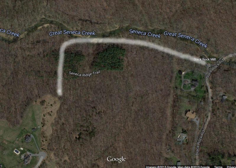 |
|
|
|
Post by Tweek on Jul 28, 2015 19:18:43 GMT -6
I was waiting for someone with the correct info to post it, as I haven't been there and didn't know which parts of the original post were wrong. That map looks pretty good. twana should be happy now.
|
|
|
|
Post by Monrozombi on Jul 28, 2015 19:22:04 GMT -6
I will rewrite everything and if that one is to be pinned go ahead
|
|
|
|
Post by Tweek on Jul 28, 2015 19:25:37 GMT -6
Cool. Start a new thread with it and that can be the official one.
|
|
|
|
Post by Monrozombi on Jul 28, 2015 19:27:22 GMT -6
Stickman Forest Pull out of the parking lot at Black Rock mill and make a right on black rock road. Take that to Rte 28 aka Darnestown Road, turn right. The road will fork, take the fork to the left towards Rte 107 aka Whites Ferry Road. Take Whites Ferry Road to Sugarland Road, it should be your first left Follow sugarland road. Its a small road. When you get to a weird looking intersection take the left, that becomes Monteverde Road. Take Monteverde Road over a one lane bridge that is right before a hard 90 degree right hand turn there should be a winery or estate to the left. As soon as you take that right go up a few hundred yards until you see a parking lot for a trail, park there. Once you park in the lot, go back to Monteverde road and turn right. THERE IS NO SHOULDER be careful but head back the way you came until you just about come up on that 90 degree turn which would now be going to your left. There is a little pull off area where you will see a trail. Take that trail. Take the trail back into the woods until you see the woods open up and you will see it go off to the left towards Seneca Creek. Take the path to your right. You will walk this path for a few minutes and you will begin to see the pine trees starting in on your left. The path will go up hill a little bit. Start looking to your left and you should see some of the stickmen we left hanging in the woods. This is where the stickmen were hung originally. 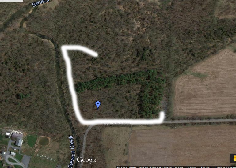 |
|
|
|
Post by Monrozombi on Jul 28, 2015 19:28:17 GMT -6
The directions above will probably lead you to a path that meets the one you're on coming from your right, just say left. There are a few paths you will cross on your intial walk to your right but i am not certain at this time which is the right one. I will make a video and film the whole walk to the stickmen on my next trip
|
|
|
|
Post by Pentagram on Aug 1, 2015 16:03:28 GMT -6
i am sorry i should really take a night and write out everything and I want to do that. I do have the ambition to do it, just not time. Here is the location of the cemetery of rocks. When you park at Black Rock Mill there is a trail right next to the mill. Follow that for a few hundred yards. After a while you will notice a large hill on your left that seems quite steep and it is. Turn left off the trail and head up the hill. There is no trail. When you get to the top to the clearing go to the left hand corner. This is where they found the rock piles and rocks in the tree. Unfortunately there are none left but this where Ed led me on the first expedition there. My map skills are crude and i apologize
Very interesting . Maybe next time I'll try it.
I assume you mean the trail is behind the mill.
I was thinking to go there to walk .I went to several trail a few kilometers. I traveled a lot Seneca Creek.
For example, I went to the other side.
There are interesting places.
No one can know whether some of the movie was filmed where I went. It looks similar to camping places they did, for example.
Change to HD
|
|
jmexplorations
rock pile disturber
 Do whatever makes you feel alive!
Posts: 81
|
Post by jmexplorations on Oct 17, 2020 8:38:28 GMT -6
Stickman Forest Pull out of the parking lot at Black Rock mill and make a right on black rock road. Take that to Rte 28 aka Darnestown Road, turn right. The road will fork, take the fork to the left towards Rte 107 aka Whites Ferry Road. Take Whites Ferry Road to Sugarland Road, it should be your first left Follow sugarland road. Its a small road. When you get to a weird looking intersection take the left, that becomes Monteverde Road. Take Monteverde Road over a one lane bridge that is right before a hard 90 degree right hand turn there should be a winery or estate to the left. As soon as you take that right go up a few hundred yards until you see a parking lot for a trail, park there. Once you park in the lot, go back to Monteverde road and turn right. THERE IS NO SHOULDER be careful but head back the way you came until you just about come up on that 90 degree turn which would now be going to your left. There is a little pull off area where you will see a trail. Take that trail. Take the trail back into the woods until you see the woods open up and you will see it go off to the left towards Seneca Creek. Take the path to your right. You will walk this path for a few minutes and you will begin to see the pine trees starting in on your left. The path will go up hill a little bit. Start looking to your left and you should see some of the stickmen we left hanging in the woods. This is where the stickmen were hung originally. Thank you for these awesome directions! We are going to attempt going there next weekend to do a Halloween filming location special for our YouTube channel. We are not sure what we will find but it will be fun! We will definitely be respectful to the town of Burkittsville and the other locations as we heard that they are not very receptive to Blair Witch visitors!! Thanks again and any other info you have would be helpful! We will be getting your book tomorrow so that should be helpful!  |
|
|
|
Post by Monrozombi on Oct 17, 2020 8:43:27 GMT -6
I honestly have a much better way now to get there. Takes less than a minute. I’ve learned a thing or two since posting
|
|
jmexplorations
rock pile disturber
Do whatever makes you feel alive!
Posts: 81
|
Post by jmexplorations on Oct 17, 2020 8:59:05 GMT -6
I honestly have a much better way now to get there. Takes less than a minute. I’ve learned a thing or two since posting Well any help will be much appreciated!! |
|
jmexplorations
rock pile disturber
Do whatever makes you feel alive!
Posts: 81
|
Post by jmexplorations on Oct 17, 2020 9:53:47 GMT -6
I honestly have a much better way now to get there. Takes less than a minute. I’ve learned a thing or two since posting Well any help will be much appreciated!! Also, we have a pretty successful YouTube channel so when we put this video in we will DEFINITELY promote your book!!! 😊 |
|


